
Copyright 2019 © Communications Management Group, L.L.C.
All Rights Reserved


Wireless Infrastructure
Engineering, Support, & Coverage Maps
612-


Radio System Coverage Maps (Worldwide Terrain Data)
Radio System Coverage Maps represent estimated radio system coverage by utilizing Propagation Software. To create the coverage models, this tool considers factors such as frequency, distance, transmitter power, receiver sensitivity, antenna height, antenna gain, variations in terrain, signal obstructions, ambient noise, and interference. Coverage Maps are an Invaluable System Engineering Tool.

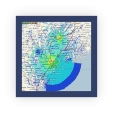
SINGLE SITE
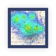
MULTI SITE
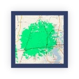
CONTOUR STUDY
WHAT IF?
Single Site Maps calculate coverage to and from a Single Repeater or Base Station Site and the Mobile and Portable radios.
Network / Multi Site Maps calculates coverage to and from Multiple Repeater, Base Station, or Voting Receiver Sites and the Mobile & Portable radios.
Contour Studies use pre-
We are often asked “What If.” It is less expensive to have us build your system in the virtual world first. We can help you design the system that fully meets your needs.